It’s like a Scandinavian Pride Rock, or at least something out of a religious flick. Rocketing out of the sheer cliff face, sharp, grey, and just waiting to be walked on.
QUICK FACTS
Distance (round trip): 22km (14 miles)
Elevation gain: 900 meters (2956 ft)
Camping: Allowed
Difficulty: Medium
WHEN TO GO
The trail is generally accessible between mid June and Mid September, otherwise prepare for a lot of snow. However, this year (2015) turned out to unusual, with a blanket of snow covering about 90% of the trail.
GETTING THERE

Coming from Bergen – There are busses that will take you from Bergen to Odda in different ways. The most efficient way to travel is on the 930 BUS from Bergen Busstajon to Odda Busstajon. Check here for schedules with Skyss, the main bus company. There will be at least one ferry between Bergen and Odda. There also will be at least one bus transfer as well. Once the bus reaches Odda, you can TRANSFER (no need for another ticket) to Tyssedal on another bus. From here, there are a few options to reach the Skjeggedal area and the Trolltunga Trailhead. One would be to hoof it and walk. It’s about 7km (4.3 miles) in total, but you will be walking up hill. Another option is to hitchhike, which in Norway, and particularly that area, is VERY safe. We also heard about small buses, and taxi services that will take you up as well, just speak to a local in the store in Tyssedal.
Coming from Oslo – You can take a train to the town of Voss. Then a bus down to Odda. Once the bus reaches Odda, you can TRANSFER (no need for another ticket) to Tyssedal on another bus. From here, there are a few options to reach the Skjeggedal area and the Trolltunga Trailhead. One would be to hoof it and walk. It’s about 7km (4.3 miles) in total, but you will be walking up hill. Another option is to hitchhike, which in Norway, and particularly that area, is VERY safe. We also heard about small buses, and taxi services that will take you up as well, just speak to a local in the store in Tyssedal.


THE TRAIL
The trailhead is near a large parking lot, 7km (4.3 miles) from Tyssedal, Norway, and near a dam for the Ringedalsvatnet Lake. The trail is 11 km (7 miles) from the trailhead to the Trolltunga, about 22km (14 miles) in total. In the first 1.5km, the trail rises 410 meter through a thick forest, with a large cascading river to your right. Fixed ropes and some handy stone masonry help along the way, as the trail is quite steep, and can be slippery with mud and running snow melt.


At the top of the climb, the trail flattens out into the Måglitopp; A rolling, gentle bowl of land protected on three sides by high ground. Some locals have small to large cabins ranging from rustic little one room cabins, to full size houses located up here. The trail crosses a few brooks and streams, but you can rock hop most if not all of them. If there is still snow on the ground, your feet will get wet. At this point all the trees have fallen back, and you are quite exposed for the rest of the trail.


At the other end of the Måglitopp, the trail continues to the Gryteskaret, a steep mountain pass about 4km into the trail and at 1182 meters (3877ft) above sea level. The trail is steep in this section, but manageable unless snow covered. If snow covered, then just walk straight up the best way you think. Some hikers even had crampons or micro spikes, and carried ice axes, but Legs and I did it in trail runners and were fine (some slipping and sliding).


At the Gryteskaret, the trail starts to head down again. Gently sloping down like one of those pink, super slides you see at a carnival, it heads into the Store Floren. Here, the views really begin to open up, with the Folgefonna glacier to the west, and the precipitous drop to the lake in the distance, drawing nearer with each step. For us, the ‘trail’ for this entire part was nothing but a swathe of footprints in the snow. Other hikers have mentioned evidence of old architecture, and dry river beds when there isn’t snow covering the trail. Past the ’emergency shelter’ which is nothing more than a trashed, and gutted cabin, the trail rises steeply again, this time reaching the highest point on the trail at 1214m ( 3982ft). With the drop off to your right, the trail dips and crests a few times, the deepest of which, a dry river bed, and dam to your left. From here the trail travels in mostly one direction, a few hundred meters away from the drop off. It is very easy, and recommended to walk to the cliff edge, and look down at the glacial lake and features. Finally, when the cliff edge turns, the trail follows it for one more kilometer to the amazing Trolltunga. Enjoy!


AT THE TROLLS TONGUE
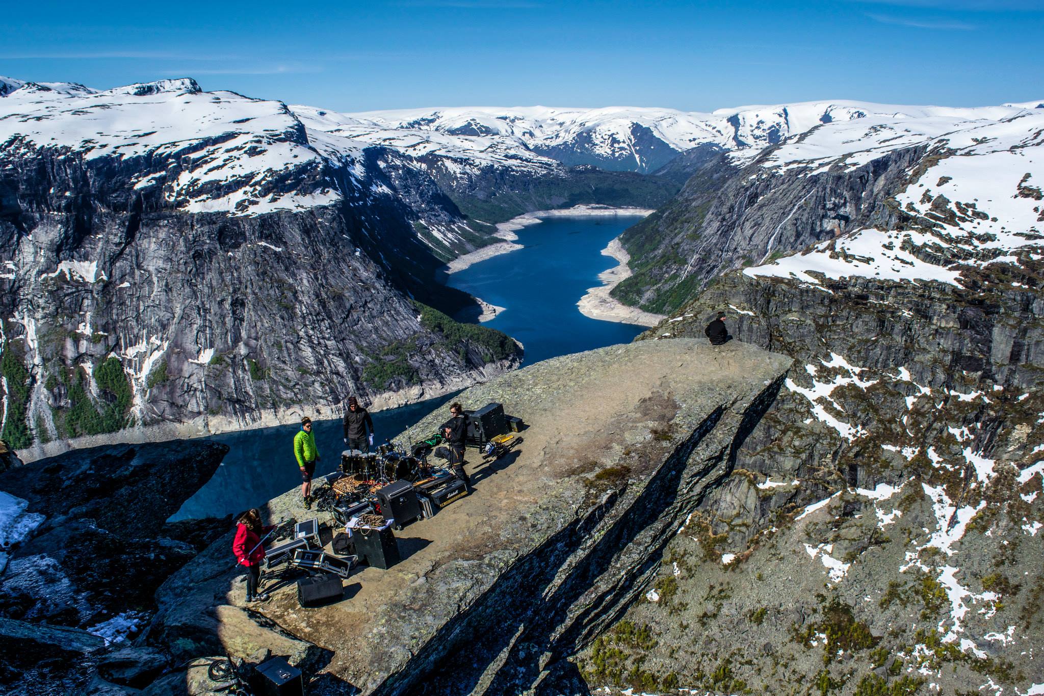
The Trolltunga really is an amazing rock formation, but it also probably the most known image of Norway in the world. Up to five hundred people can hike to the Trolltunga in a day, with some nightmarish stories about waiting hours for ten seconds on the rock before having to get off for the next person. That being said, there are ways to escape the crowds. Choosing what time of the year to go is pivotal. We went on the summer solstice, which had mixed results. Although unusual, the amount of snow was somewhat of a problem, slowing us down considerably, and limiting our ability to camp with our tarp tent (needs places for stakes). However, there were much fewer people on the trail as opposed to later in the summer. We got to the Trolltunga at about 8am, and although we were the first people there. We had ample time to hang out on the ledge, and take a ton of pictures. We were also able to post up at another (arguably better) spot, and hang out for five hours.


When on the Trolltunga ledge, BE VERY FREAKING CAREFUL! A 24-year-old women fell to her death trying to take a picture on the ledge. If you keep your head, and don’t take any big risks, you should be ok. Some people like to sit on the ledge with their legs dangling off. This makes a great picture, but is dangerous. The ledge is sloped up, so it’s not easy to just roll/fall of the edge, but I can’t stress enough to be careful. Especially then the area is crowded. At the end of our time on the ledge, a norwegian metal band began setting up for a performance/video and make things a bit trickier. Also, it was really annoying.
(Disclaimer: The Trolltunga is an awesome spot to take a picture, and the hike to it is fun and not too crazy. It’s social media presence is also making it very popular and known. BUT! Only people who are physically up to the challenge, and comfortable at such heights, should attempt to go out to the ledge. There are guide services that will take you the entire way in both directions for added safety if needed.)
BETTER THAN THE TROLL’S TONGUE?
If you were looking in the same direction the Trolltunga is pointing toward, there is an incredible spot to hang out, and even camp if you’re daring enough. It’s much more stable, and easy to navigate than the Trolltunga, but has the same amazing view. We were able to hang out for five hours and no one disturbed us. After you get your Trolltunga shot, score a seat here and watch the day go by.


CAMPING ON THE TRAIL
Norway has the “Right to Roam” which means you can camp pretty much anywhere, as long as you are a few hundred meters away from the closest home, and not on private property. Even then, asking the land owner if you can camp on a corner of their land in not uncommon. At the top of the first climb, there are camping spots to the right of the trail, before the river. At the Måglitopp, where the locals have there cabins there are plenty of places to camp if there is no snow as flat ground, and great water sources are not hard to find. When we went, the snow was cause for concern because we use a tarp tent, and thus needed soft ground to use stakes. We found a bare patch, with the help of a local. Up the Gryteskaret, and over the pass was completely covered in snow for us, but had plenty of flat ground if not covered in snow. However, the better camping spot are along the cliff edge. Not only because of the amazing views, but because large boulders offer some protection from the wind. REMEMBER! There are no trees up there, so proper wind protection is a concern. Just behind the Trolltunga, there are spots to camp as well, giving you the opportunity to be one of the first people to see the ledge that day.


Wow! Absolutely stunning photos 🙂
Hi !
When did you take that pictures? In June?
Yes June!