Start Point: Daleville, VA — Mile — 728.1
End Point: Glasgow, VA — Mile — 784.9
April 25th, 2017
Daleville, VA to Bobblets Gap Shelter
18.5 miles

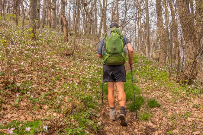
We left Ron and Kim’s house early, stomachs filled with bacon, pesto, roasted veggies, chicken, and strawberries. The sky was iron grey , but the worst of the rain had passed. We walked, north on a bland stretch of trail, crossing many roads, and having no real climbs. After some wet, hard days, and new shoes for Legs, we welcomed the boring trail. Though the rain had stopped, everything was still dripping wet. The trail was often quite narrow and overgrown, forcing us to walk through a gauntlet of vines and branches that would paint moisture onto our bodies and packs. Legs made the horrifying discovery about how permanently wet hands are basically torture. After she said that, all I could think about was having dry hands. Then I would rub my hands on my shirt, which was wet, and suffer more.

The rain from the previous days caused several creeks to feel rather full of themselves. Instead of small rock hops, or jumpable creeklets, we had full fledged, shoes off, fords. We caught up with with Strider, and Wet Wipes at the first ford. They took a look at it, and thought it would be a better idea to eat.
Legs slipped on her Crocs, and easily walked across the mirky, rushing water. For those without camp shoes, like Strider, Wet Wipes, and myself, this would be the first time on the AT where we were hiking barefoot. Glim-Glom, of course, just walked through in his socks and Chacos.
The fords weren’t crazy, nor were they dangerous, but I did feel giddy stepping across the flood waters. This is what real adventures are made from, barefoot in murky water, with a pack on your back. Pinch me. Meanwhile, we can hear the traffic of a major highway buzzing in the distance. I wonder how many people in those cars know there is a small group of people in the woods, talking about the merits of Crocs.
The day would finish sunny, which made the Blue Ridge Parkway Vistas rather beautiful. Until we reach Waynesboro, and Shenandoah NP, we will be criss crossing with the BRP for almost 100 miles.


We camped at Bobblets Gap Shelter, a common looking shelter, undistinguished and not worthy of extra note.
April 26th, 2017
Bobblets Gap Shelter to Cornelius Creek Shelter
18.5 miles

You can always tell how uncomfortable the day is going to be, by how comfortable you are in the morning. For example, if you wake up warm and comfortable, then you can be assured the day is going to be miserable. Today, was no different, as I woke up warm and content. It was terrifying; 7am and already t-shirt weather already.
I have a love/hate relationship with pine needles. On one hand, they remind me of some of the best parts of the PCT. On the other hand, they remind me of the PCT. Sometimes, my heart skips a beat when the smell of hot, baked, pine needles enters my nose. I’m brought back to the Battle of Northern Cali, when days hovered around 95. Today, I smelled those needles, and was transported back to 30 mile waterless stretches, and isolation. Then, I would look up and see Legs, and all would be well.

We stopped at Jennings Creek, where there is a noted swimming hole in AWOLs guide. We soaked our weary legs, and ate. Maybe it was the heat, our full stomachs, or the accumulated miles, but we were spent, and it took a long time, and a lot of motivation to leave the creek. Eventually we left, but our pace would be slow for the rest of the day.

We climbed Fork Mountain, a small peak with no view, and came down the northern side. There we stopped at the brand new, and incredible, Bryant Ridge Shelter. Multi-tiered, with great ‘living space’, and light, it was nicer than my apartment in Brooklyn. If you can plan it out, stay there, and hit the 5 mile climb first thing the next day. We did those 5 miles, and it wasn’t ideal at the end of the day.
April 27th, 2017
Cornelius Creek Shelter to Glasgow, VA
19.9 miles

We were hiking by 7am to get in as many miles as possible before the midday heat. The day started with Apple Orchard Mountain. It was clear, and the climb was basic. Apple Orchard has a mediocre view, and was crowded with day hikers. There is also one of those FAA towers up there, so it’s not one of the nicest summits.
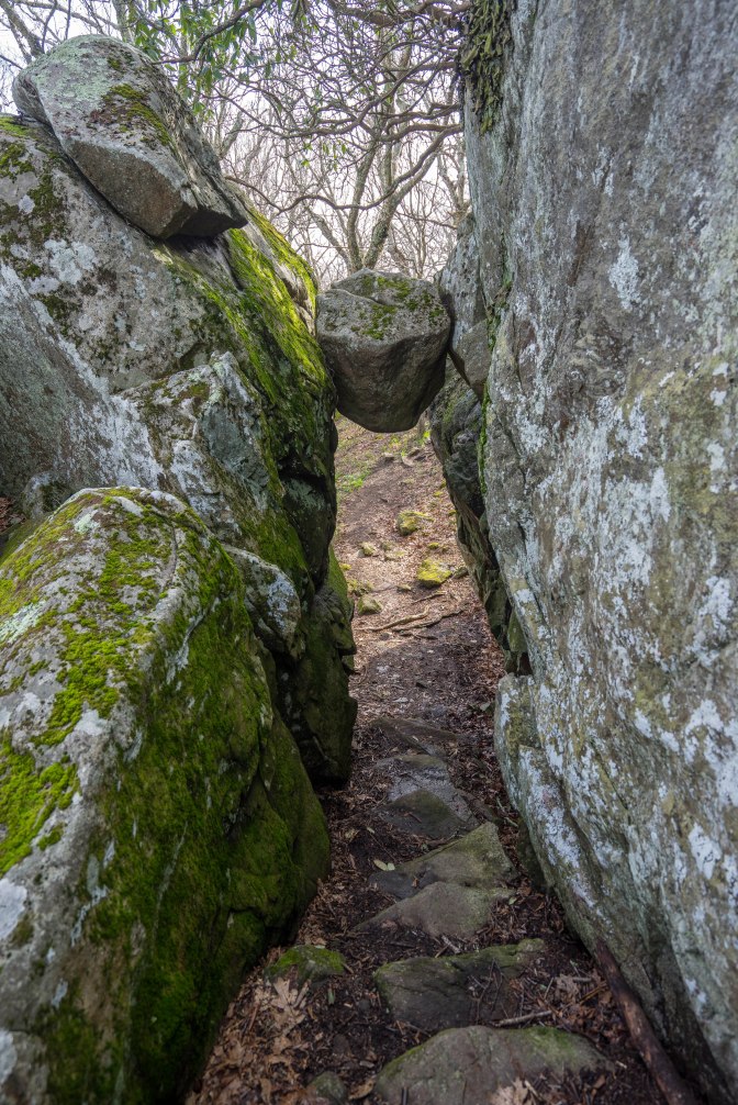
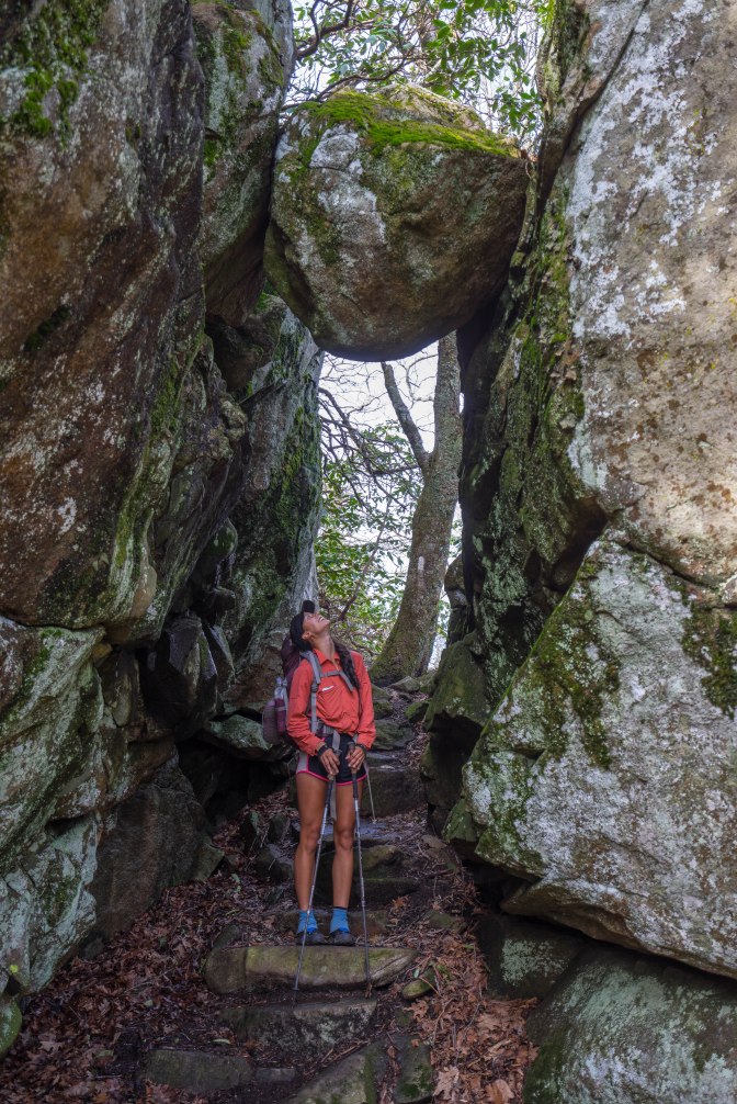
We stopped at the famous Guillotine, not far after the summit of Apple Orchard Mountain. Here the trail narrows between two rock walls. Wedged at the far end of these walls is a large, pointed boulder. It hangs perfectly over the trail, and will fall one day. As humans, we stand underneath it and take photographs. I’ll never understand it.
All day, fickle weather. Moments from a typhoon, to sunny skies. Still, I’d take a storm over oblivious day hikers. One old lady didn’t let us pass for at least .1! POINT ONE!

Hikers, you’ve been warned. The hitch into Glasgow is a certified cluster f**k. Lack of traffic, a good shoulder, and a sharp bend in the road make for a tough hitch. We got lucky and caught some day hikers leaving at the same time as us.
