The contrast between the Alabama Hills, and the eastern escarpment of California’s Sierra Nevada mountains is something to behold. Below; smooth, earth tones abound, as stacks of monzogranite boulders lay scattered in all directions. Above; a sharp, blue wall of glowing granite, with Mt. Whitney serving as the highest spear tip. Tucked into the labyrinth, hide natural arches. 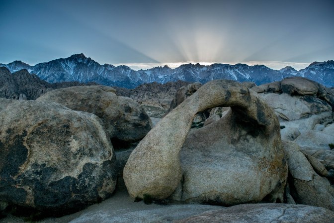
It was in the Alabama Hills where you can enter a world of hiking, mountain biking, and horse travel. Where famous movies like Gladiator, Django Unchained, and The Lone Ranger were filmed. While there, enjoy limited crowds, free camping, and some of the best night skies you can imagine! Throw in a compass of adventure (I’ll explain later), and this small, but sweet area can be connected with a plethora of awesome adventures. To name a few- Mt. Whitney, Kearsarge Pass, Death Valley, hidden hot springs, and Yosemite National Park!
THE ADVENTURE & TRAIL:
At a very short .7 of a mile, The Mobius Arch Trail may not seem like it has a lot to offer. I would agree with you, IF we were just talking about the trail by itself. Instead, let’s consider the Mobius Trailhead as a staging platform for a larger scale adventure!
The Mobius Arch is one of the more famous natural arches found within the area, due to it’s size and the way it frames Mount Whitney, the highest peak in the lower 48. It’s dramatic curve, view, and easy location to reach make it a spot for photography enthusiasts from all over the world. In mid March we didn’t have to battle against crowds, as we bumped into less than 20 people, and most of those people were either day visitors, or sleeping in tucked away RV’s. We were the only campers around, which made for a very private, and incredible spot near the Mobius Arch. LIKE THIS!

After parking in the dusty lot (roads are generally unpaved in the area), we began to hike on the trail. The trailhead isn’t necessarily marked, but it’s very intuitive, and the beginning of the Mobius Trail is lined with stones.

The trail is short, but it doesn’t matter as you will be snapping photos left and right. If you come at the later part of the day, you can catch the last rays of light spilling over the Sierra, and bathing the White Mountains to the east in a golden light. There are also a near infinite amount of side passages, ravines, gullies, and boulder heaps to keep you entertained as you make your way past all the arches. The two ones directly on the trail are Lathe Arch, and obviously, the Mobius Arch, and they are right near each other. Once you’ve done the whole trail, take one of the side passageways and see where you can get to. We explored past sunset, scampering up to boulder tops, and slithering into skinny ravines, all while the stars began popping out.
HOW TO GET THERE:
The closest town is Lone Pine, a small, but full service town on highway 395. There is food, gas, and even a small outfitter/hostel. You can get some gear and stove fuel, at the outfitter, but it is limited. Alabama Hills is west of Lone Pine, via Whitney Portal Road. After 2.7 miles on Whitney Portal Road, turn right onto Movie Flat Road. In 1.5 miles, you will come to a parking lot area. Be aware, Movie Flat Road turns into dirt, and can be a little bumpy. Also, there isn’t any real signage, so it’s more intuitive, getting to the parking area.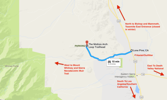
A LADDER OF ADVENTURE:
Ok so the Alabama Hills are sweet and all, but it’s not one of those, stay multiple day kinda places, unless you’re content on mountain biking. Rather, the Alabama Hills is just one rung, in a ladder of adventure. Placed almost perfectly between several national parks, the Pacific Crest Trail, and some hidden gems (think hot springs), the Alabama Hills can be paired with some of the worlds most unique locations. To name a few, Death Valley National Park, Sequoia/Kings Canyon National Parks, and of course Yosemite National Park. I recommend spending half a day and a morning at the Alabama Hills, on your way to do something cool at one of these other spots. For example, Legs and I connected a Tahoe and Death Valley Trip, with a stop at the Alabama Hills.
NORTH! SOUTH! EAST! WEST! ANY DIRECTION IS A GOOD ONE!
WEST!
Looking for a long hike with a big finish? Head directly west to the Mount Whitney Portal, where you can hike up to the Summit of Whitney (weather permitting), and sit at the highest point in the contiguous United States, 14,508 feet! *Pro Tip!* Add to the experience, by starting at Horseshoe Meadows, south of Whitney Portal, and taking one of several trails a few miles to the Pacific Crest Trail. Hike the PCT 22.5 miles north to Crabtree Meadows, and then another 8.4 miles east, to the summit of Whitney. The cherry on the cake is a sunrise summit of Whitney, after sleeping at Guitar Lake (4 miles below the summit). If camping there, it’s a 4 mile slog up steep switchbacks, where you can leave your pack at Trail Crest (a junction), and continue up to the summit in the last 1.8 miles. Enjoy unbroken views to the east, as the sun explodes over the White Mountains. Generally, the summit wont be too crowded at this time, though in thru hiker season, expect more than you think. When you come down, pick up your pack at Trail Crest, and instead of hiking back down to Guitar Lake, head east, and down to Whitney Portal. (PLEASE NOTE YOU WILL NEED A PERMIT TO DO THIS!) Remember to give yourself enough time to get to the summit before the sun starts rising, as it is only 4 miles from guitar lake, but a very steep, and at a high altitude. (Mt. Whitney, of course, can be day hiked from the Whitney Portal and back (very strenuous hike), but make sure you have a permit.)
NORTH!
Looking for a sweet day hike, or quick overnighter? Head north on 395 from Lone Pine to the town of Independence. Turn west, towards the Onion Valley Trailhead/campground. Park there, and take the Kearsarge Pass Trail/Bubbs Creek Trail up and over Kearsarge Pass to Kearsarge Lakes, and Bullfrog Lake (and eventually the John Muir Trail/Pacific Crest Trail). The hike to the top of Kearsarge Pass is around 5 miles, and though continuously upward, it is pretty well graded. Another 2-ish miles gets you to Bullfrog Lake, which makes for an incredible camping spot. Take the same trail back up Kearsarge, and down to the Onion Valley Trailhead (14 miles RT). (OR!!! Walk south to Mexico, or North to Canada on the Pacific Crest Trail.)
Looking to try your hand in Yosemite? Head north on 395 until Lee Vining, where you turn west on HW120. This is Tioga Road/Tioga Pass and is subject to closure if there is snow. I recommend getting gas at the station right after you turn onto 120. This route will take you up and over Tioga Pass, through Tuolumne Meadows, and past Tenaya Lake (in that order). Your first view of Yosemite Valley will be from Olmstead Point, after Tenaya Lake, which isn’t the greatest view of the Valley, but still pretty amazing. If you are looking for hikes, there are many different trailheads beginning on 120. From east to west, some hikes include Lembert Dome, Lyell Canyon, the John Muir Trail down to Yosemite Valley, and Clouds Rest. If you want to see some Giant Sequoias, your best shot in the park for the next year is Tuolumne Grove near Crane Flat. Mariposa grove will be closed until 2017. Tuolumne Grove is only a micro grove with less than ten Giant Sequoias, but is a great 2.5 mile lollipop loop, passing some amazing trees, and some fallen sequoias via an old Logging Road. The rest of Yosemite, and Yosemite Valley can be reached from that point onward.
(Little Secret Spot to know about – The run off of Keough Hot Springs (a fee based establishment) has a couple of pools tucked into the landscape outside of the companies property. The pools are comfortably hot, but under some power lines, so the ambience isn’t perfect. But, with the right people, it can be super cool. Buy a bunch of glow sticks and throw them in at night for a cool look. Head west off of 395 just outside the southern limits of Bishop towards the signed Keough Hot Springs. The LAST RIGHT before you actually enter the real property, is where you get off. It’s up to you to figure it out from there!)

SOUTH/EAST!
Want to test yourself in extreme climates and landscapes? Head southeast to Death Valley! From Lone Pine, head south on 136, which eventually heads east via 190 towards Panamint Springs and Stovepipe Wells. Hit the Mesquite Sand Dunes, Golden Canyon, and Badwater Basin while you’re there. Just beware of freakish temperatures, and blaring sunlight. Death Valley holds the record for the highest ever recorded air temperature at 56.7 C (134 F). I’ve been there in March and May. March temperatures hovered around 95+ degrees, and in May, the thermometer hit 116 degrees down at Badwater Basin! Badwater Basin also holds the distinction of being the lowest altitude in North America. In high summer, expect temperatures over 120 degrees.
SOUTH!
Beaches, cities, or climbing? You can’t go wrong! Head on down to southern California. Santa Barbara, Los Angeles, and best yet, San Diego are all great cities to explore. If you’re still looking for some outdoor skullduggery, maybe head over to Joshua Tree, or the Imperial for a little climbing, hiking, and some of the best star gazing in the United States.
